MARTA is the major public transportation operator in the Atlanta metropolitan area. Created in 1971 as a strict bus system, MARTA runs a network of bus routes connected by 48 miles (77 km) of rail track with 38 subway stations. MARTA is the eighth-largest rapid transit system in the United States by ridership.
MARTA operates almost entirely in Fulton, Clayton, and DeKalb counties. However, they retain bus services to two destinations in neighboring Cobb County, such as Six Flags Over Georgia and the Cumberland Transfer Center next to the Cumberland Mall. MARTA also offers Mobility, a paratransit service for customers with disabilities, through the Doraville Station Ride Gwinnett buses.
Table of Contents
Atlanta Metro Overview
- Length: 48 mi (77 km)
- Stations: 38
- Lines: 4
- Track gauge: 4 ft 8+1⁄2 in (1,435 mm)
- Speed: 70 mph (110 km/h)
- Owner: Metropolitan Atlanta Rapid Transit Authority (MARTA)
- Operator: Metropolitan Atlanta Rapid Transit Authority (MARTA)
- Start date: February 17, 1972
Atlanta Metro Route
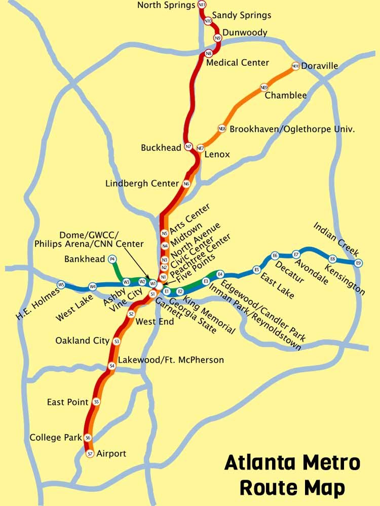
MARTA Rail is a 48-mile, 77-kilometer-long metro system in Atlanta, Georgia, with 38 stations and four lines (Red, Gold, Blue, and Green).
The Red and Gold lines are in a north-northeast alignment, while the Blue and Green lines are in an east-west alignment. Five Points station, the only station on the network that allows users to transfer to any line, connects to all four lines.
Atlanta MARTA Operational Metro Lines
Red Line
- Route: North Springs – Atlanta Airport
- Stations: 19
Stations List: Airport, College Park, East Point, Lakewood / Fort McPherson, Oakland City, West End, Garnett, Five Points, Peachtree Center, Civic Center, North Avenue, Midtown, Arts Center, Lindbergh Center, Buckhead, Medical Center, Dunwoody, Sandy Springs, North Springs
Gold Line
- Route: Doraville – Airport
- Stations: 18
Stations List: Stations: Airport, College Park, East Point, Lakewood / Fort McPherson, Oakland City, West End, Garnett, Five Points, Peachtree Center, Civic Center, North Avenue, Midtown, Arts Center, Lindbergh Center, Lenox, Brookhaven/Oglethorpe, Chamblee, Doraville
Blue Line
- Route: Hamilton E. Holmes – Indian Creek
- Stations: 15
Stations List: Hamilton E. Holmes, West Lake, Ashby, Vine City, Dome / GWCC / Philips Arena / CNN Center, Five Points, Georgia State, King Memorial, Inman Park / Reynoldstown, Edgewood / Candler Park, East Lake, Decatur Avondale, Kensington, Indian Creek
Green Line
- Route: Bankhead – Edgewood / Candler Park
- Stations: 9
Stations List: Bankhead, Ashby, Vine City, Dome / GWCC / Philips Arena / CNN Center, Five Points, Georgia State, King Memorial, Inman Park / Reynoldstown, Edgewood / Candler Park
Atlanta MARTA Metro Route Map

Atlanta MARTA Metro Ticket Prices (Fare)
MARTA’s one-way fare is currently $2.50. New Breeze cards are $2. Breeze Tickets carry an extra fee of $1 for single-use only. Passengers over 65, passengers with disabilities, and Medicare recipients will receive a discounted fare of one dollar. One-way paratransit fares are four dollars. Ten full-fare one-way trips can be $25, and twenty full-fare trips can be $42.50.
MARTA also offers several transit pass options for unlimited travel: a 24-hour pass is $9, a 2-day pass is $14, a 3-day pass is $16, a 4-day pass is $19, a 7-day pass is $23.75, and a 30-day pass is $95.
- Regular Fare (one-way trip): $2.50
- Children (46 inches and under): Free
- Senior Citizens, Disabled Riders & Medicare Recipients: $1.00
Atlanta MARTA Metro Hours (Timing)
Train Hours
- Weekday: 4:45 AM – 1 AM
- Weekend: 6 AM – 1 AM
Train Frequency
- Rush Hours: 20 min (6-9 AM & 3-7 PM)
- Non-Rush Hour: 20 min
- Nights & Weekends: 20 min


