The strategy of not building infrastructure around the border areas for a long time caused much damage to the country. Despite China’s aggressive tendencies, not paying attention to the connectivity of the rest of India from the areas of the LAC is proving to be a grave mistake.
To rectify this mistake, the prevailing critical authorities operate very rapidly at the border infrastructure. The Modi Gov is thinking about a five-year plan to put a community of roads alongside the LAC in Arunachal Pradesh.
This will be one of the biggest and most difficult projects in the country.
Table of Contents
Arunachal Frontier Highway Overview
- Length: 1748 km
- Cost: ₹27,000 Crore
- Deadline: 2027
- Route: Bomdila-Vijaynagar
- Starting Point: Bomdila
- Ending Point: Vijaynagar, Changlang district
About Arunachal Frontier Highway
Under this project, a 1748 km-long two-lane road will be made. The road lying 20 km close to the border will be developed as ‘Frontier Highway’.It will also be known as NH-913.
The Arunachal Frontier Highway project will start from Bomdila. which will cross Monigong Pass, Huri Pass, and Nafra Pass. These 3 points are very near to the India-Tibet border.
China will also go through points located near Jido and Chenquenti near the border. It ends at Vijaynagar near the India-Myanmar border. This entire highway will be divided into 9 packages.
In the next five years, the government will build a new Frontier highway in Arunachal Pradesh, which will pass close to the India-Tibet-China-Myanmar border.
At some places, this ‘Frontier Highway’ will be close to 20 km from the China border.
The Union Road Transport Ministry will build this 1,748 km long two-lane road, which is of great strategic importance and aims to prevent migration of people from border areas.
This will be the longest proposed national highway that the Center has notified in one go in recent times. Given the repeated intrusion attempts of China in Arunachal, this road will be very important for the uninterrupted movement of border security forces and defence equipment along the border.
About 800 km of the corridor will be greenfield, and other than this will be brownfield. More than this, there will be some bridges and tunnels. A government official said, We have planned to complete all the approval works of this project in 2024-25. That it normally takes around 2 years to complete the construction.
As we move forward, different packages will be completed, while the entire project is expected to be completed by 2026-27. In 2016, the ‘Empowered Committee on Border Infrastructure’ approached the Ministry of Road Transport and Highways. Steps were recommended for the preparation of Detailed Project Reports (DPRs) based on the alignment finalized by the Department of Border Management under the Ministry of Home Affairs, in consultation with the Ministry of Defense and the State Government.
Included Corridors
- Thelamara-Tawang-Nelia Highway – 402 km
- Itakhola-Pakke-Kesang-Seppa-Parlo Highway – 391 km
- Gogamukh-Taliha-Tato Highway – 285 km
- Akajan-Jorjing-Pango Highway – 398 km
- Pasighat-Bishing Highway – 298 km
- Kanubari-Longding Highway – 404 km
Arunachal Frontier Highway Route
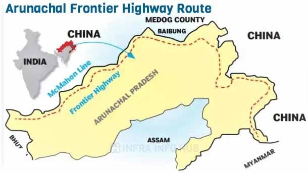
The high-altitude highway will originate from Mago-Thingbu in Tawang district and meander through the following border areas of Arunachal Pradesh along the McMahon Line: West Kameng district; East Kameng district; Upper Subansiri district; Mechuka in West Siang district; Tuting in Upper Siang district; Dibang Valley district; Desali in Lower Dibang Valley district; Chaglagam, Kibithu, Dong and Hawai all in Anjaw district; and end at Vijaynagar in Changlang district at the junction of Arunachal Pradesh, Assam, Nagaland, and Myanmar.
Importance of the Project
Under this project, India has covered 2 thousand km. Is building a long road that runs along the McMahon Line. This Highway will start from Mago in Arunachal Pradesh, adjoining Bhutan, and pass through Tawang, Upper Subansiri, Tooting, Mechuka, Upper Siang, before ending at Vijaynagar near the Myanmar border. Will pass through Debang Valley, Desali, Chaglagam, Kibithu, and Dong.
In this way, the Line of Actual Control (LAC) adjacent to Arunachal Pradesh will be completely connected to a highway. An estimated Rs 40,000 crore will be spent on this project. With the completion of this project, Arunachal Pradesh will have three National Highways – Frontier Highway, Trans-Arunachal Highway, and East-West Industrial Corridor Highway.
Strategic Value
This project is extremely important strategically, given the radical changes in Arunachal Pradesh’s road connectivity. He said that the army would benefit from the road project as well.
The Yangtse, the site of Chinese PLA troops’ incursion on December 9 of last year, will be close to the construction of the Frontier Highway.
The road will begin at Bomdila, travel through Nafra, Huri, and Monigong, which are near the McMahon Line or LAC, and end at Vijayanagar, which is close to the border between India and Myanmar.
Parts of the road will also be connected to Tawang, Mago Upper Subansiri, Upper Siang, Mechuka, Tuting, Dibang Valley, Kibithu, Changlang, and Dong.
According to the plan, the road will also connect to the under-construction Trans-Arunachal Highway. It is a two-way, approximately 1,811 km-long standard national highway that connects Tawang in the south to Kanubari on the north-western tip of Arunachal Pradesh. – The eastern end of the state, close to the Bogibeel bridge near Dibrugarh in Assam, ends near Akajan on NH-52.
In addition, 1,000 km-long roads will be constructed, connecting district headquarters, important places, and some villages.


